
NHAI has already invited bids for 4 Lane access controlled, 423 KM long Atal Expressway which is also known as Chambal Expressway as well. Here is detailed information about the status of the Chambal expressway, the Chambal Expressway Map and much more. Chambal Expressway will connect Kota (Rajasthan) with Etawah (Uttar Pradesh) and will reduce the current travel time of 08.30 hours to just 3.5 hrs.
Basic information of Atal Progressway (Chambal Expressway)
Chambal Expressway or Atal Expressway is a new greenfield expressway which will pass from Rajasthan, Madhya Pradesh and Uttar Pradesh as a part of Bharatmala Pariyojana.
- Project Length – 423 KM
- Lanes – 4 (2 on each side)
- Speed Limit – 120 Kmph
- Project Cost – 23,000 cr (Approx)
- Status – Out of 4 Packages, 2 packages (packages 3 and 4 ) are in Bidding Status)
- Deadline – 2027
- Highway Model – Hybrid Annuity Model (HAM)
- Owner – NHAI (National Highways Authority of India)
Chambal Expressway Route Map
As per the Chambal Expressway route map, The Chambal Highway will start from Kota, Rajasthan. From Kota it will go to Bhind, then Morena, Gwalior, Shivpuri and will end at Nanawa Village in Etwawah, UP. As per the latest information, Land Acquisition for the entire stretch of Chambal Eway to be completed by May 2023.
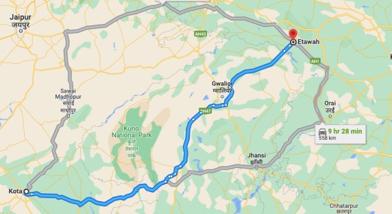
Chambal Expressway Route Map in Rajastahan
It starts from Kotra Deepsingh Village, Digod. At a point, The Chambal Expressway will be connected to Delhi – Mumbai Expressway near Kota Interchange. 72 Km route of the Chambal Expressway will be in Rajasthan and After Digod, Atal Expressway will pass from Pipalda Kalan, Bijaipur. After that from Sheopur, this expressway will enter Madhya Pradesh. In Madhya Pradesh, it will stay the longest for 306 Km.
Chambal Expressway Route Map in Madhya Pradesh
In Madhya Pradesh, It will pass from Sheopur, Morena, Bhind, and Gwalior districts. The Total Lenght of the Expressway in MP is 306 km. At many points, this expressway will run parallel to the Chambal River. In the route of this expressway, one interchanged will be made to connect it with Agra – Gwalior Expressway as well.
Chambal Expressway Route Map in Uttar Pradesh
From Merhi Dudhi Village of Bharthana, it will enter Uttar Pradesh. From Bharthana to Etawah, The total length of the expressway in UP is 47 km.
Tenders & Contractors Status of Chambal Expressway
The Atal Expressway work is divided into 4 Packages. Below are details of the Tenders and Contractors who working on 4 Packages of the Chambal expressway.
| Package Number | Contractor |
|---|---|
| Package 1 | To Be Decided |
| Package 2 | To Be Decided |
| Package 3 (60.9 Km) | Bidding Underway |
| Package 4 (51 km) | Bidding Underway |
Current Status of Chambal Expressway
Currently, Land Acquisition is going on in Rajasthan and Madhya Pradesh. The bidding is underway for 113 Km Long packages. Keep visiting us For more updates on Atal Expressway.
Also read:-
- Jewar Airport Map, Location
- Mumbai Ahmedabad Bullet Train Route Map
- Upcoming Vande Bharat Express Trains Starting Date