
One of the notable infrastructures of the Maharashtra Government is the famous Mumbai metro. After being fully functional, the metro will cater to the need of all the citizens who want to enjoy the benefit of affordable and seamless transportation. However only one line of the Mumbai metro route is functional owing to the delay in the environmental clearances, land acquisition, and project approvals and the name of the metro is the Versova-Andheri-Ghatkopar.
Mumbai Metro Key Notes
- Currently Operational – 46.5 Km
- Under Construction – 147.02 Km
- Approved – 21.28 Km
- Proposed – 136.4 Km
Out of the Mumbai metro map all lines, the Navi Mumbai metro is said to have the smallest of the trains with three cars that will be expandable to six of the coaches in the Maharashtra state. In terms of Mumbai metro status, this metro is functional now.
Mumbai Metro – Currently Working and Under Construction Routes
| Line | Terminals | Length (in KM) | Stations | Current Status |
|---|---|---|---|---|
| Line-1 | Verova – Andheri – Ghatkopar | 11.4 | 12 | Operational |
| Line-2A | Dahisar (E) – DN Nagar | 18.60 | 17 | Operational |
| Line-2B | DN Nagar – Mandale | 23.64 | 22 | Under Construction |
| Line-3 | Cuffe Parade – BKC – Seepz – Aarey Colony | 33.50 | 27 | To Start in DEC 2023 |
| Line-4 | Wadala – Kasarawadavali | 32.32 | 32 | Under Construction |
| Line-4A | Kasarawadavali – Gaimukh | 2.88 | 2 | Under Construction |
| Line-5 | Thane – Bhiwandi – Kalyan | 24.95 | 17 | Under Construction |
| Line-6 | Swami Samarth Nagar – Vikhroli | 15.18 | 13 | Under Construction |
| Line-7 | Dahisar (E) – Andheri (East) | 16.5 | 14 | Operational |
| Line-7A | Andheri (E) – CSI Airport | 3.17 | 2 | Under Construction |
| Line-9 | Dahisar (E) – Mira Bhayander | 11.38 | 8 | Under Construction |
Mumbai Metro – Approved and Proposed Lines Routes
| Line | Corridor | Length (in Km) | Stations | Status |
|---|---|---|---|---|
| Line-8 | CSIA – NMIA | 35 | 7 | Proposed |
| Line-10 | Gaimukh – Shivaji Chowk in Mira Road | 9.20 | 4 | Approved |
| Line-11 | Wadala – Chhattrapati Shivaji Maharaj Terminus | 12.77 | 10 | Proposed |
| Line-12 | Kalyan – Taloja | 20.7 | 17 | Proposed |
| Line-13 | Shivaji Chowk – Virar | 23 | 20 | Proposed |
| Line-14 | Kanjurmarg – Badlapur | 45 | 40 | Proposed |
Mumbai Metro Route Map of Operational Routes
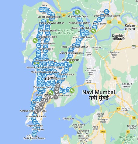
Line 1 (Blue Line) (11.4)
The following are the Line 1 Mumbai metro stations:-
DN Nagar, Versova, Andheri, Azad Nagar, Andheri, Airport Road, Western Express Highway, Chakala, Marol Naka, Asalpha, Saki Naka, Jagruti Nagar and Ghatkopar.
On the Mumbai metro map, it is known as the blue line where the operational line usually connects Versova with Ghatkopar via Andheri. The key routes that are connected through the metro are the areas that are in the western suburbs. This Mumbai metro route which is 11.4 km long is rightly elevated.
Line 2 (Yellow Line) (42 KM)
The following are the line 2 Mumbai metro stations:-
IC colony, Kandarpada, Dahisar, Eksar, Borivali West, Pahadi Eksar, Kandivali West, Valnai, Dhanukarwadi, Malad (West), Lower Malad, Oshiwara, Goregaon Metro, Pahadi Goregaon, Andheri West and Lower Oshiwara.
This line is also known as the Yellow line and it is 42 km long. It is divided into further two sub-sections which are the Mumbai metro line 2A and the Mumbai Metro line 2B. In terms of the Mumbai Metro Line 2A, it will be somewhere 18 km corridor between the Dahisar-Charkop-DN Nagae along with the 17 Mumbai metro stations. On the other hand, the 2B section will link the DN Nagae-BKC-Mankhurd and its length will be somewhere around 23.5 km.
Line 3 (Aqua Line) (33.5)
The Mumbai metro line map of Line 3 is the following:-
Girgaon, Cuffe Parade, Vishan Bhawan, Badhwar Park, Churchgate, Hutatma Chowk, Mahalaxmi, Grant Road, Mumbai Central, Worli, Dadar, Dharavi, Income Tax Office BKC, Santa Cruz, Vidyanagri, Aarey Colony, Mumbai international airport, Sahar road, MIDC, SEEPZ and Marol Naka.
This line also goes by the name Aqua line and it is 33.5 km long and is fully underground. In terms of covering distance, it does that between the Cuffe Parade in South Mumbai and SEEPZ and the Aarey in north Mumbai. Moreover, it will be having around 26 total underground Mumbai metro stations where one will be at the grade station.
Line 4 (Green Line) (34 km)
Manpada, Majiwada, Tikuji-ni-wadi, Dongripada, Vijay garden, Kasaradavali, Shangrila, Cadbury junction, Bhandup, RTO Thane, Mahapalika Marg, Teen Hath Naka, Gandhi Nagar, Naval Housing, Bhandup Nagarpalika, Pant Nagar, Mahal Junction, Suman Nagar, Bus Depot, Bhakri Park, Laxmi Nagar, Shreyas Cinema, Wadala Truck Terminus and Siddharth Colony.
This line also goes by the name, The Green line and it mainly connects the Kasarvadavli in Thane to the Wadala which is situated in south-central Mumbai. This route promises to boost the connectivity between Thane and Mumbai and also the local train network.
Line 5 (Orange Line) (17 km)
The following are the Line 5 Mumbai metro stations:-
Bhiwandi, Kather, Kalian APMC, Sahajanand Chowk, Durgadi Fort, Kalyan Station, Temghar, Anjur Phata, Kasheli, Gopal Nagar, Kon Gaon and Balkumbh Naka.
This metro route of Thane-Bhiwandi-Kalyan is also recognized as the Orange line. It is said that there will be a huge cost of Rs. 8,416 crores to build it. Furthermore, it will be having a total number of 17 Mumbai metro stations.
Line 6 (Pink Line) (13 Km)
The following is the list of Line 6 of Mumbai Metro stations:-
Adarsh Nagar, JVLR, Swami Samarth Nagar, Vikhroli, IIT Powai, SEEPZ Village, Ram Baug, Kanjurmarg West, Momin Nagar, Mahakali Caves and Shyam Nagar.
This line of the Mumbai metro route is known as the Pink line and it is said to link the western suburbs that lie in the eastern ones of the metro corridor.
Line 7 (Red Line) (16 Km)
The following are line 7 Mumbai metro stations:-
Hub Mall, Kurar Village, Mahindra and Mahindra, Thakur Complex, Shrinath Nagar, Dahisar East, Bandongri, V Nagar, Aarey Road Junction, Vitt Bhatti Junction, Borivali Omkareshwar, Andheri West, Shankarwadi, JVLR Junction and Mahanand Bombay Exhibition.
This is also known as the Red line and it is somewhere around 33.5 km long. This particular route is said to have 29 Mumbai metro stations where 14 are deemed to be elevated and the rest will be underground.
Line 8 (Gold Line) (7 Km)
Line 8 also known as the Gold line will link the Navi Mumbai Airport and the Mumbai Airport. The length of the metro route is said to be somewhere around 32 km and in terms of expense, it will somewhere cost around Rs 15,000 crore.
Line 9 (Red Line Extension) (8 km)
The following are the line 9 Mumbai metro stations:-
Deepak Hospital, Zankar Company, Amar Palace, Dahisar east, Pandhurang Wadi, Sai Baba Nagar, Subash Chandra Bose Station and Shahid Bhagat Singh Garden.
It is the extension of Line 7 and the expense for the corridor would be somewhere around rs. 3,600 crores. It will be connecting Galmukh-Shivaji Chowk.
Lines 10, 11, 12, 13 and 14
The extensions of the Mumbai metro line 4 is the lines 10, and 11. It is mainly known as the Green line. It will be acting as the link between the Gaimukh and Shivaji Chowk. The extension of Line 5 would be the Mumbai Metro Line 12. It will be linking the Kalayn to the Taloja. Apart from that, Line 13 is also there which is said to be around 23 km long in terms of the Mumbai metro route. The expense is estimated at around 6,900 crores. Finally, Line 14 is said to be the Magenta Line. It will be linking the Vikhroli with the Kanjurmarg and hence elongating the Ambernath-Badlapur.
Conclusion
The Mumbai Metropolitan Development Authority or MMRDA implemented the Mumbai metro project. By keeping the busy local train system of the busy city in mind, the government of Maharashtra planned to implement the Mumbai metro project from the year 2006. These are everything that was there to know about the Mumbai metro route map.
Also read:-
- Chambal Expressway Route Map
- Jewar Airport Map, Location
- Mumbai Ahmedabad Bullet Train Route Map
- Upcoming Vande Bharat Express Trains Starting Date